Map of Malaysia
The interactive Google map of Malaysia below will be used throughout the website. Since we can easily add markers pointing to interesting locations, make sure to check it out every once a while. You can use this map to navigate through Malaysia. Use your mouse to slide the map to a location. Use the buttons to zoom in or out, or to switch from regular view, to satelite view (or both). You can also double click on the map to zoom in onto the location you're pointing at. In the near future we will add maps of all provinces of Malaysia, and list all highlights of that province.
This map can also function as your starting point for exploring Malaysia. You can click on the markers to get to the corresponding pages of this website.
Malaysia consists of two parts; Peninsular Malaysia and Borneo (also called Borneo-Malaysia). Clearly visible on the map is the famous (toll charge) north-south expressway, and a huge national park; Endau Rompin. If you zoom in two times, you'll see the islands of Langkawi and Penang on the map. Both can be found in the northern part of the peninsula. Click here for a full screen version of the interactive map of Malaysia.
On this page:
- Map with cities
- Map with states
- Map with islands
- Map with highlights
- More information about Malaysia
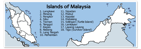
Cities of Malaysia
Below the map with all major cities of Malaysia. The cities mentioned are all worth a visit.
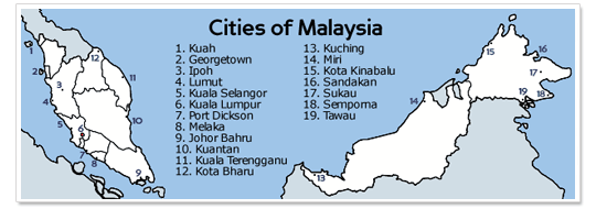
States of Malaysia
Check out the maps of all states of Malaysia: Johor, Kelantan, Melaka, Negeri & Sembilan, Pahang, Penang, Perak, Perlis & Kedah, Sabah, Sarawak, Selangor and Terengganu.
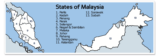
Islands of Malaysia
Below you can see a map of Malaysia with the most beautiful (and popular) islands.
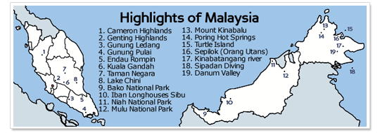
Highlights of Malaysia
Below the map with all highlights of Malaysia. Of course there are many more attractions to visit or to do in Malaysia, but on this map the most popular highlights are mentioned.
Pages with information about Malaysia
- Climate and monsoon
- Country information
- Facts and details
- Flora and fauna
- Food and famous dishes
- Geography
- History and historical facts
- Hygiene and healthcare
- Newspaper headlines
- Politics and political system
- Population and demographics
- Public holidays and national festivals
- Top 10 highlights and attractions
- Tourism events
- Visa information
